Hunt for treasure in the GeoCache Dash!
What's it all about and how does it work?
 What if you found an activity that was fun for everyone, that didn't cost much to participate except for your time, that got your kids to enjoy math, science and exploring the outdoors, and also promised an opportunity to see parts of Maine that are close by — yet you probably didn't even know existed?
One of the fastest growing activities worldwide is geocaching. Geocaching is a popular game of hide and seek, of treasure hunting, using GPS technology to locate given coordinates where caches are hidden. Families, friends and individuals of all ages can participate in this low impact, high enthusiasm outdoor activity. More than 300 caches are hidden and waiting to be found in Waldo County, and more than 9,000 caches are hidden throughout Maine. So it's no surprise to think that a lot of people are out and about looking for those caches... and yet many people haven't heard of geocaching, don't know what they are looking for and aren't sure how to find one.
A cache can contain just about anything and be hidden anywhere. For example, there is a cache hidden in every state park in Maine. How much fun it would be to give yourself a challenge to find each one of those, with the added bonus of being able to visit all the beautiful Maine state parks on your quest.
Geocaching is a real-world, outdoor treasure hunting game using GPS-enabled devices, including smart phones. Participants navigate to a specific set of GPS coordinates and then attempt to find the cache in its container hidden at that location. So there's the math part of the game - understanding and using the coordinates and employing billion dollar satellites and a GPS device to find the cache. There is free or low cost software you can download on your smart phone or you can buy a basic GPS device to get started. GPS coordinates will only get you so close to the cache, so there is usually a hint or two given to help hone in on the prize.
But before y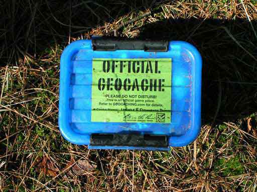 ou put on your walking shoes and head out the door, go to geocaching.com , the official Global GPS Cache Hunt Site, and watch the introductory videos. There are lots of helpful hints on getting started, and you can even sign up for a free basic membership and enter your zip code to find geocaches in your area or an area you want to explore.
When you click on the cache site you want to look for, you get driving directions and, of course, those all important coordinates. There will likely be some information about the site and the container and maybe some hints of what to look for. All caches are supposed to be on public land and of course, hidden so as to not disturb the environment. And seekers should not do anything during their hunt to disturb the natural enviornment either.
Inside most cache containers there will be a log book to sign and date. Once found, put the cache back where you found it and move on the find another. And inside many caches, there might be something to take as a souvenire, but the finder is also expected to leave something in its place, so bring a stash of some geocache coins, marbles and other small trinkets in your backpack before setting off on your hunt.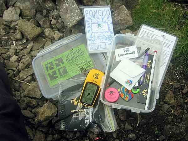
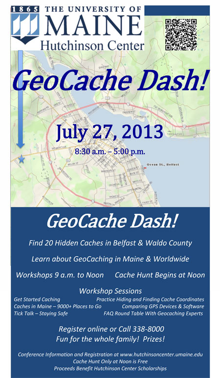
So why are we telling you all about geocaching? The Hutchinson Center in Belfast is holding the GeoCache Dash! Conference Saturday, July 27, from 8:30 a.m. to 5 p.m. The morning includes workshops, from 9 a.m. to noon, for geocache and GPS beginners as well for experienced geocachers. Following lunch, the coordinates for 20 new caches hidden in Waldo County will be revealed and the hunt will be on. The geocache hunt is from 1 to 4 p.m., with logging of finds from 4 to 5 p.m. followed by prize awards. The cost of the conference is $50, and includes a variety of workshops and lunch. There is no cost to participate in the afternoon geocache hunt only.
There will be prize drawings for those who find some or all of the caches, with sponsors providing some great prizes. All the proceeds will support scholarships for Hutchinson Center students, so join in the fun. It will be a great time for the entire family or get a group of friends together and join the adventure of geocaching in the Midcoast.
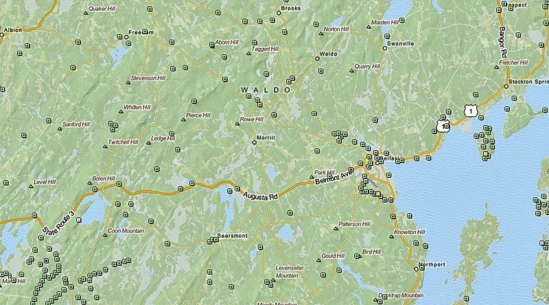
Every square on the map snapshot below of Waldo County is a geocache location waiting to be found, with coordinates listed on geocaching.com. WIthin 10 miles of Belfast's zip code, there are 120 geocaches, within 25 miles of 04915 there are 736 geocaches. The GeoCache Dash! is free to join the hunt for the 20 new geocache coordinates that will be revealed after lunch on Saturday at the Hutchinson Center. All you have to do is register and pick up a passport and start entering in those GPS coordinates. If you need some help and know-how, sign up for the morning workshop and you'll be ready to hit the geocache trail by noon. What are you waiting for?
Geocaching 101
Welcome to the geocaching community! If you still have questions after reviewing this information, visit Geocaching.com for more information and forums.
The Game
What is geocaching?
Geocaching is a real-world, outdoor treasure hunting game using GPS-enabled devices. Participants navigate to a specific set of GPS coordinates and then attempt to find the geocache (container) hidden at that location.
How is the game played?
At its simplest level, geocaching requires these 8 steps:
• Register for a free Basic Membership at Geocaching.com.
• Visit the "Hide & Seek a Cache" page.
• Enter your postal code and click "search."
• Choose any geocache from the list and click on its name.
• Enter the coordinates of the geocache into your GPS Device.
• Use your GPS device to assist you in finding the hidden geocache.
• Sign the logbook and return the geocache to its original location.
• Share your geocaching stories and photos online.
There are many other levels to the game. Keep reading the guide to learn more.
What are the rules of geocaching?
~ If you take something from the geocache (or cache), leave something of equal or greater value.
~ Write about your find in the cache logbook.
~ Log your experience at www.geocaching.com.
What do I need to go geocaching?
The only necessities are a GPS device or a GPS-enabled mobile phone so that you can navigate to the cache, and a geocaching.com membership.
Where are geocaches located?
Geocaches can be found all over the world. It is common for geocachers to hide caches in locations that are important to them, reflecting a special interest or skill of the cache owner. These locations can be quite diverse. They may be at your local park, at the end of a long hike, underwater or on the side of a city street.
Are there different types of geocaches?
Yes. There are currently over a dozen "cache types" in geocaching, with each cache type being a different variation of the game.
Getting Started
What kind of cache should I look for on my first adventure?
Cache Type: Traditional
Difficulty Rating: 1
Cache Size: Regular or Large
You should also check to see that other geocachers have recently logged finds on the cache page (also called the cache listing). This indicates that the geocache is most likely still in place and findable. Find logs are indicated on the cache page with a smiley face.
Searching for geocaches
You can search for geocaches by location or by GC Code (a unique code associated with each cache listing) from the geocaching.com homepage, the Hide & Seek page or the Advanced Search page. Premium Members can sort search results by caches with the most favorite points, difficulty of find, terrain rating and more.
Loading coordinates onto your GPS device
The method of loading coordinates onto your GPS device varies depending on what type of device you have.
Inputting Coordinates by Hand
If your device does not connect directly to the computer via an interface cable, you will need to enter coordinates into the device by hand. This process will be different for each device. Check your device's manual for instructions.
Send to GPS
If you have a DeLorme, Magellan or Garmin that connects directly to your computer through an interface cable, you can use the "Send to GPS" functionality to send a cache listing directly to your GPS device. The first time you use this functionality, you will be instructed to download the appropriate plugin for your GPS device.
Download LOC or GPX file
If you have any model of GPS device with an interface cable, you can download the cache listing as a LOC file (Basic Members) or GPX file (Premium Members). LOC files contain basic information about a cache, including coordinates, cache name and difficulty and terrain ratings. GPX files are available for Premium Members and include all of this data as well as the cache description, hints and the 20 most recent logs. Premium Members can also download up to 1000 caches in a single GPX file using the Pocket Query feature.
For most GPS devices, you will need to download third-party geocaching software to read LOC or GPX files. Some devices, like the Magellan Triton and Garmin Colorado, support and read Geocaching GPX files directly.
Finding Geocaches
What does a geocache look like?
Geocaches vary greatly in size and appearance. In the field you will see everything from large, clear plastic containers to film canisters to a fake rock with a secret compartment. So, how do you find the cache?
The first step is to get a general idea of the cache's size. The size is shown on each cache page. A general overview of the cache size graphic is found below. Please note that these are just examples; sizes can vary.
• Micro - Less than 100ml. Examples: a 35 mm film canister or a tiny storage box typically containing only a logbook or a logsheet. A nano cache is a common sub-type of a micro cache that is less than 10ml and can only hold a small logsheet.
• Small - 100ml or larger, but less than 1L. Example: A sandwich-sized plastic container or similar.
• Regular - 1L or larger, but less than 20L. Examples: a plastic container or ammo can about the size of a shoebox.
• Large - 20L or larger. Example: A large bucket.
• Other - See the cache description for information.
(Small, Regular and Large containers typically contain trade items.)
What's usually in a cache?
In its simplest form, a cache always contains a logbook or logsheet for you to log your find. Larger caches may contain a logbook and any number of items. These items turn the adventure into a true treasure hunt. You never know what the cache owner or visitors to the cache may have left for you to enjoy. Remember, if you take something, leave something of equal or greater value in return. It is recommended that items in a cache be individually packaged in a clear, zipped plastic bag to protect them from the elements.
Quite often you may also find a Trackable, a sort of geocaching "game piece" that you can learn more about below.
What should not be placed in a cache?
People of all ages hide and seek geocaches, so think carefully before placing an item into a cache. Explosives, ammunition, knives, drugs and alcohol should not be placed in a cache. Respect local laws at all times.
Do not put food or heavily scented items in a cache. Animals have better noses than humans, and in some cases caches have been chewed through and destroyed because of food items in a cache.
How do I find the cache and what should I do once I've found it?
There are many things to know about searching for a cache. For instance, did you know that there is a slight "error" to every GPS device due to technological limitations? Your device can get you close to the cache, but there are a number of things to consider as you get closer to the cache location.
When you find the cache, sign the logbook and return it to the cache. You can take an item from the cache if you like - just make sure to leave something of equal or greater value in its place. When you are finished, put the cache back exactly as you found it, even if you think you see a better spot for it. Finally, visit the cache page to log your find and share your experience with others.
Can I move a cache once I find it?
Please do not move a cache from its original location. If you feel that the cache may not be located in the correct location, please email the cache owner directly or post a log on the cache listing page, notifying the owner of your concern. Cache owners are responsible for maintaining their cache placements.
What should I do if I discover that a cache has gone missing?
If you visit a cache location and the cache is missing, make sure to log the cache with a "Didn't find it" log so that the cache owner is notified. Cache owners who repeatedly receive "Didn't find it" logs should check to see that their cache has not been removed.
As a geocacher, if you notice that a cache page has an unusual number of "Didn't find it" logs, please let the local reviewer know or contact us. We rely on the geocaching community to let us know the status of caches in their area.
How do I log my find?
Instructions for logging a "Found It" are located here. If you need to post another type of log, such as a "Didn't find it" or a Note, the same instructions apply, with one small change; instead of choosing "Found It" in the drop-down menu, you would choose the applicable log type.
Trackables
What are Trackables?
A Trackable is a sort of physical geocaching "game piece." You will often find them in geocaches or see them at geocaching gatherings. Each Trackable is etched with a unique code that can be used to log its movements on geocaching.com as it travels in the real world. Some of these items have traveled hundreds of thousands of miles thanks to geocachers who move them from cache to cache.
There are three main types of Trackables: Travel Bug® Trackables, Geocoins and other Trackables.
A Travel Bug is a trackable tag attached to an item that geocachers call a "hitchhiker." Each Travel Bug has a goal set by its owner. Goals are typically travel-related, such as to visit every country in Europe or travel from coast to coast. Travel Bug Trackables move from cache to cache with the help of geocachers like you.
Geocoins are customizable coins created by individuals or groups of geocachers as a kind of signature item or calling card. They function exactly like Travel Bug Trackables and should be moved to another cache, unless otherwise specified by their owners.
Other Trackable items come in various forms including patches, key rings and more. A common feature of Trackable items is that they bear a unique ID code and text noting that they are trackable at geocaching.com.
What should I do when I find a Trackable?
You are not required to do anything with the Trackable, but if you would like to interact with it, you have two options.
~ Move the Trackable
If you would like to move the Trackable to another cache, take it with you. You do not need to leave anything in its place as long as you are willing to help it on its journey. You can look up the Trackable's goal by entering its unique Tracking Code at geocaching.com/track or searching for the Tracking Code on Groundspeak's Geocaching Application. When you take a Trackable from one cache and drop it into another, it is important to log the Trackable's movements.
~ "Discover" the Trackable
When you have seen a Trackable in person, but have not moved it, you can log that you have "discovered" it. To do so, you will need to write down the Trackable's Tracking Code (the unique series of letters and numbers etched on the item).
How do I log a Trackable?
Instructions on logging a Trackable can be found at geocaching.com. If you are moving a Trackable in the real world, it is important that you also log this movement online. The steps for logging Travel Bug Trackables, Geocoins and other Trackables are the same.
Note that you should not show Tracking Codes to others or upload any photos displaying a Tracking Code. This code is only meant to be seen by those who have actually had the Trackable in their hands. If you would like to direct others to the Trackable's page, use the Reference Code on the Trackable page (it starts with TB or GC).
How do I activate a Trackable?
To activate a Trackable, visit the Activation Wizard at geocaching.com and enter the Trackable's Tracking and Activation Codes. The Tracking Code is the unique series of letters and numbers etched on the item. The Activation Code is typically found on an insert in the Trackable packaging.

History of Geocaching
On May 2, 2000, at approximately midnight, eastern savings time, the great blue switch* controlling selective availability was pressed. Twenty-four satellites around the globe processed their new orders, and instantly the accuracy of GPS technology improved tenfold. Tens of thousands of GPS receivers around the world had an instant upgrade.
Note: Selective Availability was an intentional degradation of public GPS signals implemented for national security reasons. In May 2000, at the direction of President Bill Clinton, the U.S government discontinued its use of Selective Availability in order to make GPS more responsive to civil and commercial users worldwide.
The announcement a day before came as a welcome surprise to everyone who worked with GPS technology. The government had planned to remove selective availability - but had until 2006 to do so. Now, said the White House, anyone could "precisely pinpoint their location or the location of items (such as game) left behind for later recovery." How right they were.
London, Paris, New York, Beavercreek?
For GPS enthusiasts, this was definitely a cause for celebration. Internet newsgroups suddenly teemed with ideas about how the technology could be used.
On May 3, one such enthusiast, Dave Ulmer, a computer consultant, wanted to test the accuracy by hiding a navigational target in the woods. He called the idea the "Great American GPS Stash Hunt" and posted it in an Internet GPS users' group. The idea was simple: Hide a container out in the woods and note the coordinates with a GPS unit.
The finder would then have to locate the container with only the use of his or her GPS receiver. The rules for the finder were simple: "Take some stuff, leave some stuff."
On May 3 he placed his own container, a black bucket, in the woods near Beavercreek, Ore., near Portland. Along with a logbook and pencil, he left various prize items including videos, books, software and a slingshot. He shared the waypoint of his "stash" with the online community on sci.geo.satellite-nav: N 45° 17.460 W 122° 24.800.
Within three days, two different readers read about his stash on the Internet, used their own GPS receivers to find the container, and shared their experiences online. Throughout the next week, others excited by the prospect of hiding and finding stashes began hiding their own containers and posting coordinates. Like many new and innovative ideas on the Internet, the concept spread quickly — but this one required leaving your computer to participate.
Within the first month, Mike Teague, the first person to find Ulmer's stash, began gathering the online posts of coordinates around the world and documenting them on his personal home page. The "GPS Stash Hunt" mailing list was created to discuss the emerging activity. Names were even tossed about to replace the name "stash" due to the negative connotations of that name. One such name was "geocaching."
The Origins of Geocaching
Geocaching, first coined by Matt Stum on the "GPS Stash Hunt" mailing list on May 30, 2000, was the joining of two familiar words. The prefix geo, for Earth, was used to describe the global nature of the activity, but also for its use in familiar topics in GPS such as geography.
Caching, from the word cache, has two different meanings, which makes it very appropriate for the activity. A French word invented in 1797, the original definition referred to a hiding place someone would use to temporarily store items. The word cache stirs up visions of pioneers, gold miners and even pirates. Today the word is still even used in the news to describe hidden weapons locations.
The second use of cache has more recently been used in technology. Memory cache is computer storage that is used to quickly retrieve frequently used information. Your web browser, for example, stores images on disk so you don't have to retrieve the same image every time you visit similar pages.
The combination of Earth, hiding and technology made geocaching an excellent term for the activity. However the "GPS Stash Hunt" was the original and most widely used term until Teague passed the torch to Jeremy Irish in September 2000.
The Birth of Geocaching.com
For the first few months, geocaching was confined to existing experienced GPS users who already used the technology for outdoor activities, such as backpacking and boating. Most users had an existing knowledge of GPS and a firm grasp of obscure lingo like datums and WGS84. Due to both the player base and the newness of the activity, players had a steep learning curve before going out on their first cache hunt. Tools were scarce for determining whether a cache was nearby, if one existed at all.
As with most participants, Irish, a web developer for a Seattle company, stumbled upon Teague's website in July while doing research on GPS technology. The idea of treasure hunting and using tech-gadgets represented the marriage of two of his biggest interests. Discovering one was hidden nearby, Irish purchased his first GPS unit and went on his first hunt the following weekend.
After experiencing the thrill of finding his first cache, Irish decided to start a hobby site for the activity. Adopting the term geocaching, he created Geocaching.com and applied his professional web skills to create tools to improve the cache-hunting experience. The cache listings were still added by hand, but a database helped to standardize the listings. Additional features, like searching for caches around zip codes, made it easier for new players to find listings for nearby caches.
With Teague's valuable input, the new site was completed and announced to the stash-hunting community on Sept. 2, 2000. At the time the site was launched there were 75 known caches in the world.
If You Hide It, They Will Come
Slashdot, a popular online magazine for techies, reported the new activity on Sept. 25, 2000, introducing a larger group of technology professionals to the activity. The New York Times picked up the story and featured it in its "Circuits" section in October, starting a domino effect of articles written in magazines, newspapers and other media outlets around the world. CNN even did a segment in December 2000 to profile the new hobby.
However, because there were so few caches in the world, many would-be participants discovered they didn't have a cache located and listed nearby. Many wondered whether anyone would bother looking for a cache if they hid one in their area. The growing community chanted the mantra "If you hide it, they will come" to the newer players. After some reassurances, pioneers of the hobby started placing caches just to see whether people would go find them. They did.
Through word of mouth, press articles and even accidental cache discoveries, more and more people have become involved in geocaching. First started by technology and GPS enthusiasts, the ranks of geocachers now include couples, families and groups from all walks of life. The excitement of the hunt appeals to both the inner (and outer) child. Today you can do a search on just about anywhere in the world and be able to walk, bike or drive to a nearby hidden cache.
The Creation of Groundspeak
After the increased traffic from Slashdot, Irish realized that the ongoing management of the web site would quickly outgrow the lone computer on his home DSL line. So in late 2000, he partnered with Elias Alvord and Bryan Roth, two coworkers at Sunrise Identity, to start a new company called Groundspeak Inc. (originally Grounded Inc.). With the proceeds from sales of 144 geocaching t-shirts, they moved the machines into a hosted environment in downtown Seattle. The founders continued to work for Sunrise Identity while managing the new company and the website in their off hours.
After several years of working on the web site, Irish and Alvord were able to raise enough funds through Premium Memberships to make Groundspeak a full time job. In late 2005, Roth finally became a full time employee at the company.
Irish, Alvord and Roth continue to own and operate the web site today. They are supported by a small team of Groundspeak lackeys and more than 100 geocaching volunteers worldwide.
Special Thanks...
Special thanks goes out to Sunrise Identity, which was gracious enough to support the Shop Groundspeak site in the early years, and Killerlink, which continues to help with network operations, bandwidth needs and security on the website.
Special, special thanks go to the unsung heroes who maintain and review the ever-growing list of caches listed on the web site. Additional thanks goes to Moun10Bike (Jon Stanley), for donating various Microsoft software licenses that help run the web site. Thanks Jon!
*there is no actual blue switch