Dodge Point Preserve in Newcastle
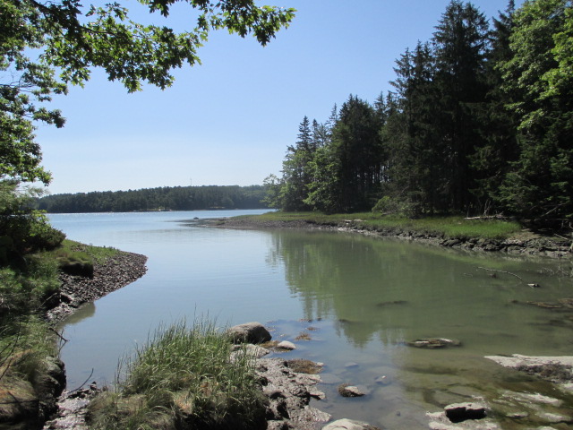
 Dodge Point Preserve in Newcastle looking from Brickyard Cove to the Damariscotta River. PHIL DI VECE/Wiscasset Newspaper
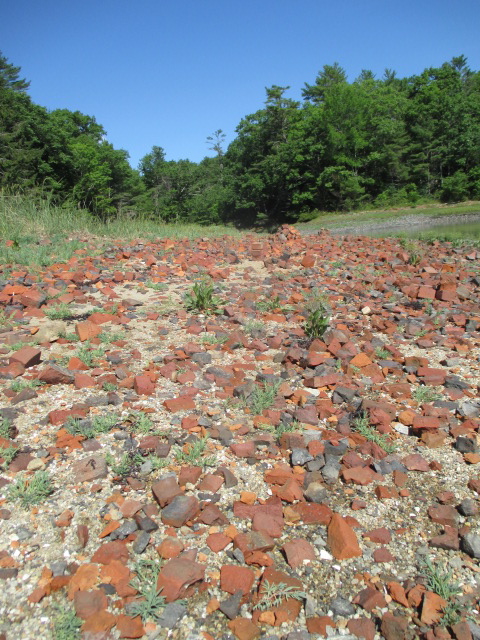
 Brickyard Beach at Dodge Point Preserve. PHIL DI VECE/Wiscasset Newspaper
 Dodge Point Preserve in Newcastle looking from Brickyard Cove to the Damariscotta River. PHIL DI VECE/Wiscasset Newspaper
 Brickyard Beach at Dodge Point Preserve. PHIL DI VECE/Wiscasset Newspaper
It’s easy to lose track of time when you’re exploring Dodge Point Preserve in Newcastle for the first time or even for those rediscovering it.
The 500-acre preserve popular with locals and visitors from away is maintained through a partnership of the Damariscotta River Association and the Maine Department of Agriculture, Conservation and Forestry. One of the nicest features is its more than 8,000 feet of water frontage to enjoy along the Damariscotta River.
Last week, the weather was perfect for being outdoors, warm but low humidity, with a nice sea breeze blowing off the water. A few other folks thought it was a good day for a walk in the woods, as well. During my visit, I met a dozen other hikers of all ages, including a couple from Texas, another from Pennsylvania and still another from Illinois.
The preserve is easy to find. From the Davey Bridge in Edgecomb, turn right off Route 1 onto Route 27 to Boothbay. Just past the Edgecomb Potters Gallery, turn left onto McKay Road. Along the way, you’ll pass the turn for the Damariscotta River Link trail system that carries you through the Schmid Preserve.
McKay Road comes out to River Road; turn left at the stop sign. You’ll soon pass the landmark yellow Merry Barn on your right, once the scene of contra dances where the late Howie Davison of Edgecomb served as the caller in the 1960s and 70s.
The turn for the preserve is just over the Edgecomb-Newcastle town line on the right and marked with a sign.
There are four trails, dry, well-packed and easy to follow. The “Old Farm Trail” serves as the main route in and out. Taking the path to the left of the kiosk carries you through a forest of mixed red and northern pines through a green canopy of mixed deciduous trees. At 0.15 miles, you’ll pass the first of several handy directional signs with a map and arrow indicating where you are.
From here the path widens into an old tote road. A stream trickles beside it on the left that leads to a small glade filled with cat o’ nine tails just beginning to turn brown.
Just beyond is a small lake that in the 19th century served as an ice pond. Long before the days of refrigeration, ice was cut here during the winter and stored in ice houses later to be sold. Not far from this area, a salt works operated here during Colonial times.
The road continues over a stone and earthen dike built years ago to form the pond. A short plank bridge spans what may have once served as a sluice. A small bench in a shaded area has been placed here where you can catch your breath and enjoy the view of the pond.
I could hear the cicadas singing in the distance, a sign mid-summer is here and autumn’s not too far off. Another was seeing the golden, brown-eyed Susans in bloom and the first signs of purple heather blossoms.
Just ahead you’ll catch a whiff of tangy salt air and soon reach the shore at a place called “Brickyard Beach.” Here you’ll see heaps of broken bricks lining the shore, the remains of yet another forgotten industry, the Dodge Brothers Brickworks. Along the muddy bank are a few rotting timbers, all that remains of a loading dock where scows and other vessels once tied up to load finished bricks.
Continuing southward on the “Shore Trail” carries you to “Pebble Beach.” You’ll find a another small beach with a huge rocky ledge resembling a beached whale and a popular place for picture-taking.
From here the path gradually runs uphill past an outcropping that rises roughly 100 feet. A short ways after crossing a tumbling stone wall, you’ll come to “Baker Landing” and a small wooden dock maintained by the DRA. The dock and landing area are open for public use. Not far from here someone had left a plastic ice shed, perhaps from last winter’s ice fishing season.
The Shore Trail eventually links up with the Old Farm Trail, which carries one back through the woods to the parking area. From the dock it’s about a 15 to 20-minute walk up and over a small rise.
Two other trails to explore are the “Ravine” and “Timber” trails. All of the trails are well-marked, easy to follow ones that beginners will enjoy. Dogs are permitted but need to be under the control of their owners. Both swimming and fishing are permitted. Fires and motorized vehicles are prohibited. Other rules are posted at the kiosk. The preserve is open year-round dawn to dusk.
If you plan to hike the entire preserve in one visit, wear a good set of trail shoes. On this visit, I spent a little more than two hours walking the trail system, although I stopped several times for picture-taking.
To learn more about the preserve or download a map, visitwww.damariscottariver.org.
Event Date
Address
United States


