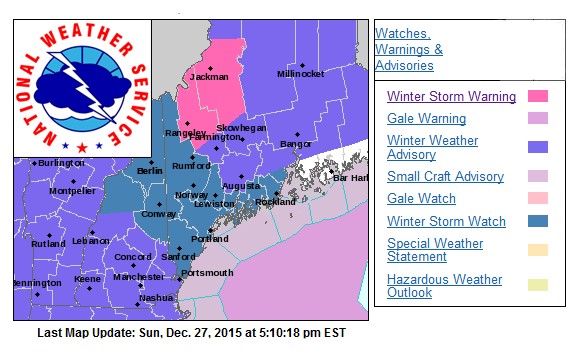
National Weather Service places Maine on winter storm watch
UPDATE: 3:30 p.m., Dec. 28: Snowfall expected to begin around 5 a.m. Tuesday, Dec. 29 and continue until around 11 a.m. Accumulation 4-7” for Portland and Midcoast area. It is expected to turn into a wintry mix and in its final transformation, icy rain. The good news: no other snow or ice in forecast for remainder of the week. It will be cold, but then, it is almost January in Maine.
GRAY — The National Weather Service Sunday evening has issued a winter storm watch for Tuesday morning into Tuesday night, Dec. 29.
The NWS said that while Sunday's storm is winding down, another storm is close on its heels, and is expected to bring with it colder temperatures and the likelihood of snow. This storm could also produce a wintry mix of precipitation, but the forecast will likely become more clear during the day Monday.
Right now, the NWS is forecasting accumulations of 6 or more inches of snow and sleet, along with some icing. The snow will develop early Tuesday morning, and continue through the afternoon, becoming heavy at times.
The snow may mix with sleep and freezing rain by later Tuesday afternoon and evening, making for slippery travel.
Temperatures will be in the lower 20s Fahrenheit, rising into the upper 20s to lower 30s on Tuesday. Winds will be northeast 5 to 15 mph, with gusts up to 25 mph.
The current winter storm watch for the Midcoast covers Knox and Lincoln counties, and coastal Waldo County. And all of Maine will be affected by this storm, with northern Maine currently under a winter storm warning, which then becomes a winter storm watch for Tuesday.
This is not the Midcoast's first brush with snow, but it will likely be a messy situation for drivers, who will be urged to use caution, go slow and allow extra time for travel, if travel is necessary.
Event Date
Address
United States


