The science of storms
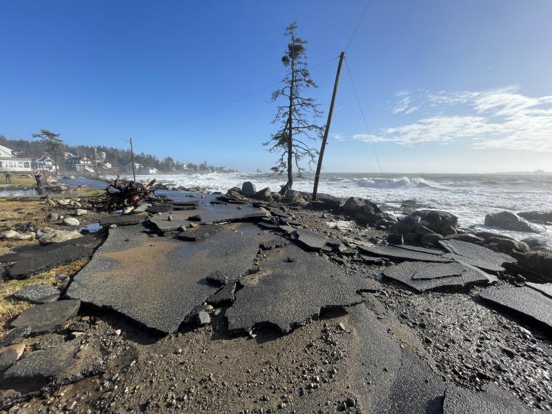
In the aftermath of the two January storms that caused widespread damage across the Maine coast, many wonder if this is the new normal. To help provide answers, Island Institute in Rockland gathered experts from around Maine for a Jan. 30 public webinar on storm science. They discussed the storms’ environmental context, how they relate to climate change and what to look for as many expect more frequent and extreme weather events.
Susie Arnold, director of the Island Institute Center for Climate and Community, said the back-to-back nature of the two storms was very unlikely, “however, these are the new types of extreme events that we do need to prepare for.”
According to Arnold and other scientists, it is hard to attribute any single weather event to climate change. She said the two consecutive storms are not necessarily the new normal, but they both were particularly destructive due to a confluence of climate change-related influences.
Arnold said it is appropriate to look at the storms in the context of global and regional warming. For one, she said 2023 was Maine’s hottest year on record. According to Hannah Baranes, a postdoctoral researcher at Gulf of Maine Research Institute, snow would be on top of frozen ground in historically normal winters, but warmer temperatures exacerbated the storms’ effects. Snow melt and ground thaw can increase soil moisture and decrease soil stability, overall increasing the potential for flood damage. In addition, Arnold said the state is getting wetter with more common flooding and heavy precipitation, not unusually accompanied by windstorms gusting over 58mph. Speakers also noted, the two consecutive January storms took place after disastrous weather and flooding in Maine’s interior weeks earlier.
According to Baranes, the coastal storms’ severity was significantly impacted by sea level rise. She said there have been about seven and a half inches of sea level rise in the past 100 years, and Maine is currently at the highest point in that period. In addition, it is likely that one or both storms resulted in the highest recorded sea level in any given area on the Maine coast, she said.
Baranas said sea level rise will increase because oceans have not yet seen the effect from the anticipated melting of the polar ice caps due to global warming. In addition, she said sea levels have been buffered by an 18.6-year cycle of the moon that makes tidal ranges rise and fall by 5 to 7.5 inches; the effect is almost at its minimum and, in about a year, it will draw the ocean upwards.
She said there have been a cluster of recent events at a time when sea level rise is in inches and, now, “it's important to consider what the impact of several feet of sea level rise might be.”
People are taking action in the face of change. Gabe McPhail spoke about her work to help communities and municipalities, locally including Lincoln County Regional Planning Commission, adapt to climate change. She said the focus is on collaborating with communities to identify priorities and vulnerabilities using local knowledge. The outcomes can be used to decide how to integrate climate action plans into capital improvement plans and fund resiliency projects. However, she said the first step is to use science to help make informed decisions.
To see some of the science on the potential impact of climate change in your area, explore these tools presented in the talk:
- National Weather Service coastal flood forecast: A forecast for flooding with implications on inundation.
- The Nature Conservancy Coastal Resilience Explorer: Explore how rising sea levels will affect roads, where routes will be inaccessible to emergency responders and social vulnerability of the communities.
- The Maine Geological Survey Sea Level Rise/Storm Surge Scenarios map: View the potential impact of sea level rise or storm surges along the Maine coastline.


