Air
About this time of year, I like to do an aerial inventory of how things look around the region. It’s just one of my weird indulgences. It helps me understand what it's like to be a bird surveying good landing spots. Thankfully, I have never had to land anywhere but Wiscasset Municipal Airport, with one exception, the grass strip at Adam’s Pond where the water company now resides. Doc Andrews and I did a few ups and downs from there! Fortunately, my takeoffs and landings were well received.
So, with the airshow in mind, I gave my old dear friend Ann Walko a call to see if I could get on her schedule. Ann and I have flown together for over 20 years. She's a great pilot and really understands how I’m hoping to line up photos. Since I don’t care to use headphones, she has come to understand my hand signals with one ear uncovered.
Ann now flies, for me, what is a luxury cruiser, a very spacious, fast and well-equipped Cessna 182. Over the years, I have flown in far less desirable aircraft. But that’s another story! Her plane is a wonderful platform, and she is very capable.
When I make a rough sketch of where I hope to fly, I need to consider which seat I will occupy, i.e., left or right and that is somewhat determined by which window opens up so I don’t need to photograph through Plexiglas. In Ann’s plane, her left window opens so I plan a route that will be well seen from the left side of the plane. In the case of this fall’s flight, our route from the airport kept Back River, Barters Island and Boothbay Common on the left side of the plane.
Continuing on to Boothbay Harbor, we circled the Harbor, then to Wall Point and up the eastern shore of Linekin Bay and on to Ocean Point via Spruce Point and Squirrel Island. After Ocean Point, we backtracked a bit to Newagen and along the eastern shore of Southport and Capitol Island which set us up perfectly for a loop around the western shore of Southport and the Sheepscot River estuaries. From there, we head back to the airport and a perfectly greased landing. It was a fine ride complicated only by passing clouds which set big shadows on the ground, annoying me and forcing an altered path.
As is often the case, aerial views reveal considerable activity and some change. From year to year it , things can evolve. Houses appear and disappear. Water bodies expand and contract. The ocean surrounds us. When I look back at old aerials it’s interesting to make comparisons. My aerial photos from the late 70s and early 80s reveal many differences. Our area is changing, that’s for sure. But we adjust.
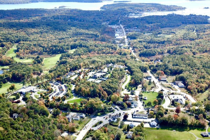
The photograph I have chosen to share is a view looking right down Route 27 from Boothbay Center to Boothbay Harbor and the ocean. You can see the pesky clouds I mentioned casting shadows. This photo was made in early October. If you look closely, you can see Fred Stover pulling out of the Hannaford parking lot in his work truck.
It was a good flight. Thank you, Ann.

